London Postcode Areas Explained - Map, Codes & How To Read
London Postcode Areas Explained simply: learn why London has no single postcode, how codes work, and how postcodes differ from boroughs.
Author:James RowleyNov 20, 2026
London Postcode Areas Explained: How The Codes Work
London postcode areas are the letter codes at the start of a London postcode, such as SW, NW, ECor WC, and they help narrow an address from a broad part of the city to a specific delivery point.
If London postcodes feel oddly cryptic, you are not alone. A code like SW1A 1AAcan look like a random string until you understand that each part is doing a different job.
In short:
- Londonuses UK postcodes, not US-style ZIP codes.
- The part before the space is the outward code.
- The part after the space is the inward code.
- The main London postal areas are E, EC, N, NW, SE, SW, W and WC.
- Postcodes are postal geographies, so they do notalways match boroughs or neighbourhoods.
- Use Royal Mail for the exact postcode of an address, and maps for area-level understanding.
- A postcode district can be useful shorthand, but it is not the same thing as a borough, neighbourhood, council boundary, school catchment or transport zone.
London Postcode Areas At A Glance
| Code | Broad meaning |
| E | East London |
| EC | East Central London |
| N | North London |
| NW | North West London |
| SE | South East London |
| SW | South West London |
| W | West London |
| WC | West Central London |
The easiest way to misread London postcodes is to treat them like neighbourhood labels. They can act like local shorthand in everyday conversation, but their first purpose is postal routing. Once that distinction is clear, the whole system becomes much easier to read.
What Is A London Postcode?
A London postcode is part of the UK postcode system. It uses letters and numbers to identify a postal delivery area, then narrows that area down to a smaller delivery unit. The Office for National Statistics describes postcodes as alphanumeric references made up of an outward codeof 2–4 characters and an inward codeof three characters.
In an address, LONDON usually acts as the post town, while the postcode area is the opening letter code such as SW, NW, E, EC or WC.
London Postcodes Are UK Postcodes, Not ZIP Codes
London does not use ZIP codes. ZIP codes are used in the United States; London uses alphanumeric UK postcodes such as:
- SW1A 1AA
- E14 5AB
- WC2N 5DU
- NW10 7AQ
If a website asks for a “London ZIP code”, it usually means “postcode”. For a real address, do not enter a generic code for London. Use the full postcode for the specific building, street or organisation.
Why There Is No Single Postcode For London
There is no single postcode for London because the city is too large and complex for one postal code. London contains many postcode areas, districts, sectors and units.
Think of the postcode like a zoom lens:
| Level | Example / What it tells you |
| Postcode area | SW / Broad postal area |
| Postcode district | SW1 / Smaller district |
| Postcode sector | SW1A 1 / Subdivision within the district |
| Full postcode | SW1A 1AA / Specific delivery unit |
The exact full postcode is the only version suitable for posting something to a precise address.
What A Postcode Can And Cannot Tell You
A postcode can help you understand roughly where an address sits in London. It can also hint at a local identity, especially in well-known districts such as SW1, W1, E14or SW19.
But a postcode cannot safely tell you everything about a place. It does not always match a borough, estate, neighbourhood, school catchment, transport zone or property market boundary.
Royal Mail’s Postcode Finder is the practical source for address-level lookup, while the ONS treats postcodes as a useful way to connect postal references with other geographies such as local authorities, wards and statistical areas.
Royal Mail also makes an important distinction: postcodes are designed for postal delivery, not to define exact geographic, neighbourhood or administrative boundaries. That is why a postcode map can be helpful for orientation but misleading if you treat it like an official area border.
Common London Postcode Mistakes
- Mistake 1: Looking for one London postcode. London has many postcode districts and full postcodes.
- Mistake 2: Treating postcodes as boroughs. Postcodes are postal geographies, not council boundaries.
- Mistake 3:Asking for a 5-digit ZIP code. London uses UK postcodes, not US ZIP codes.
- Mistake 4:Assuming district numbers show distanc London postcode numbering is historical and operational, not a perfect distance scale.
- Mistake 5:Using a nearby postcode for delivery. Always check the full postcode for the exact address.
Takeaway:A London postcode is best understood as a delivery code that can also provide useful location clues.
How To Read A London Postcode
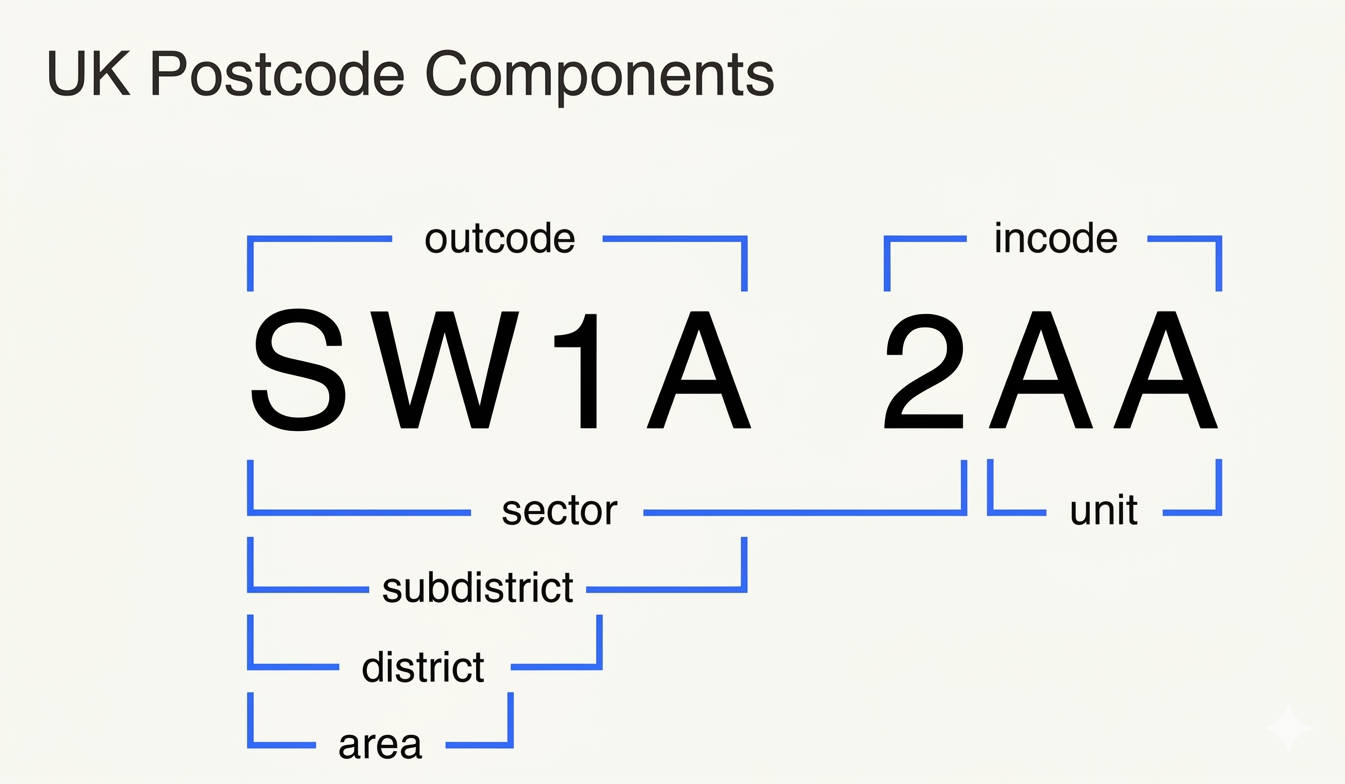
This section shows you how to decode any London postcode from left to right. The trick is to split the code at the space, then read each part in order.
A full UK postcode has two halves:
- Outward code- before the space.
- Inward code- after the space.
GOV.UK’s postcode format guidance explains that the outward postcode sends mail to the correct local area, while the inward postcode helps sort mail within the local delivery office.
The Outward Code: Area And District
The outward codeis the first half of the postcode. In SW1A 1AA, the outward code is SW1A.
It usually contains:
- Area letters, such as SW, NW, E, EC or WC.
- District number, such as 1, 10 or 14.
- Sometimes a district letter, as in SW1A or EC1A.
In London, the outward code is the part most people use conversationally. Someone might say they live in NW10, work in E14, or booked a hotel in WC2.
Some outward codes are not simple geographic shorthand. For example, certain codes can be used for large organisations, special users or high-volume mail handling, so the outward code is a strong clue, not a complete explanation by itself.
The Inward Code: Sector And Unit
The inward codeis the three-character part after the space. In SW1A 1AA, the inward code is 1AA.
It contains:
- A number identifying the postcode sector.
- Two letters identifying the postcode unit.
The inward code is much more precise than the district. GOV.UK describes the inward postcode as a number followed by two letters; the number identifies the sector, and the final letters define one or more properties within that sector.
Worked Example: SW1A 1AA
Let’s decode SW1A 1AA.
| Part | Code - Meaning |
| Area | SW - South West London postal area |
| District code | SW1 - Main district within SW |
| Sub-district code | SW1A - Smaller subdivision within SW1 |
| Sector | SW1A 1 - District plus first inward-code number |
| Unit | AA - Final delivery unit |
The key is not to overread the first letters. SWgives a broad postal direction, but the full postcode is what matters for the exact address.
Quick Decoder Table: Area, District, Sector, Unit
Use this simple method whenever you see a London postcode:
| If you want to know | Use this postcode level |
| Broad part of London | Postcode area, such as NW |
| Local postal district | District, such as NW10 |
| Small delivery sector | Sector, such as NW10 7 |
| Exact address-level delivery code | Full postcode, such as NW10 7AQ |
This is the most useful habit to build: use the right level of postcode for the question you are asking.
The Main UK Postcode Format Patterns
UK postcodes do not all follow one visible pattern. The outward code can be short or long, and some high-density London districts include an extra sub-district letter.
| Format | How to read it |
| AA9A 9AA | Example: SW1A 1AA. Outward code: AA9A. Inward code: 9AA. Common in dense London districts. |
| A9A 9AA | Example: W1A 1AA. Outward code: A9A. Inward code: 9AA. Single-letter area with sub-district. |
| A9 9AA | Example: M1 1AA. Outward code: A9. Inward code: 9AA. Single-letter area and one-digit district. |
| A99 9AA | Example: W12 1AA. Outward code: A99. Inward code: 9AA. Single-letter area and two-digit district. |
| AA9 9AA | Example: EC1 1AA. Outward code: AA9. Inward code: 9AA. Two-letter area and one-digit district. |
| AA99 9AA | Example: NW10 1AA. Outward code: AA99. Inward code: 9AA. Two-letter area and two-digit district. |
The format tells you how the code is built, but not the exact place by itself. For the exact address, you still need the complete postcode.
Postcode Components In Plain English
A UK postcode can be broken into several useful components:
- Postcode area: Example: SW. The broad postal area.
- District code: Example: SW1. The main district within the area.
- Sub-district code: Example: SW1A. A smaller subdivision, common in some dense London districts.
- Sector: Example: SW1A 1. The district plus the first inward-code number.
- Unit: Example: AA. The final two letters, narrowing delivery further.
A postcode unit may represent a street, part of a street, a group of properties, a single large user, an organisation or part of a large building. That level of detail depends on how delivery is organised for the address.
London Sub-District Examples
Some London postcodes include an extra letter in the outward code. These are known as sub-districts and are especially common in dense or high-volume parts of London.
| Sub-district | Why it matters |
| SW1A | Central Westminster and government-related addresses |
| W1A | High-density West End-style sub-district format |
| EC1A | East Central London sub-district format |
| E1W | Wapping-specific East London example |
| NW1W | North West London sub-district example |
| SE1P | South East London special/sub-district example |
These extra letters make the outward code more precise, but they still do not replace the full postcode.
Takeaway:The outward code helps you orient yourself; the inward code helps identify the delivery point.
The Main London Postcode Areas
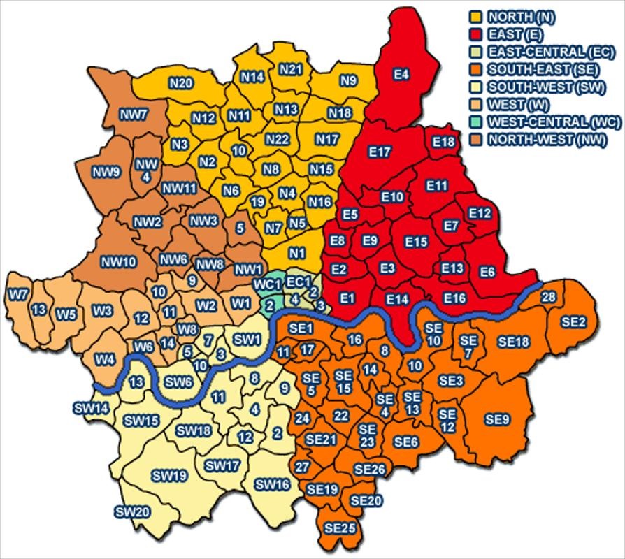
This section gives you the broad postcode map of London in plain English. These area letters are the foundation for almost every London postcode question.
The main London postal areas are:
- E- East London
- EC- East Central London
- N- North London
- NW- North West London
- SE- South East London
- SW- South West London
- W- West London
- WC- West Central London
The Greater London Authority has published postcode district maps showing how postcode districts sit across London, which is useful for visual orientation.
E - East London
The Epostcode area covers much of East London. Well-known districts include E1, E2, E8, E14, E15, E17and E20.
You will see E postcodes around places such as Whitechapel, Bethnal Green, Hackney, Poplar, Stratford and Walthamstow. As always, the exact district matters more than the first letter alone.
EC - East Central London
ECmeans East Central. It covers a compact part of central London, including areas associated with the City, Clerkenwell, Farringdon, Barbican and nearby business districts.
EC is one of the postcode areas where small differences matter. EC1, EC2, EC3and EC4each point to a different central pocket.
N - North London
The Npostcode area covers a broad sweep of North London. Examples include N1, N4, N5, N7, N10, N16and N17.
Do not assume every N postcode feels the same. N1near Islington is very different from N17around Tottenham.
NW - North West London
NWcovers parts of north-west London, including districts such as NW1, NW3, NW6, NW8and NW10.
This area includes very different London identities, from Camden and St John’s Wood to Willesden, Harlesden, Neasden and Kensal Green.
SE - South East London
SEcovers a wide part of south-east London. Examples include SE1, SE10, SE15, SE22, SE24and SE28.
The area can include places that feel central, such as parts of SE1, and places much further out, such as SE28around Thamesmead.
SW - South West London
SWcovers a large and varied south-western postal area. Examples include SW1, SW3, SW6, SW11, SW17, SW18and SW19.
The range is wide: SW1can point towards Westminster and Victoria, while SW19is strongly associated with Wimbledon.
W - West London
Wcovers parts of West London, including W1, W2, W6, W8, W10, W11and W14.
Some W postcodes are central and commercial, especially W1. Others feel more residential or local, depending on the district.
WC - West Central London
WCmeans West Central. It covers central areas such as Bloomsbury, Holborn, Covent Garden and parts around the Strand.
The main WC districts are WC1and WC2, with further subdivisions in some postcode formats.
Postcodes can also reinforce London’s broad north/south/east/west identities. For a wider cultural and geographic comparison, see our guide to North London vs South London differences.
Why S And NE Are Not London Postcode Areas Today
London’s postcode letters are historical, not a perfect modern compass. That is why London has SEand SW, but not a current London Spostcode area; it also has Nand NW, but not a current London NEpostcode area.
Today, Sis associated with Sheffield and NEwith Newcastle upon Tyne, not London. This is one reason London postcode areas make more sense when read as a postal system rather than a pure geography lesson.
Takeaway:London’s postcode letters are historical postal areas, not a perfect modern compass map.
Central London Postcodes: EC, WC, W1, SW1 And SE1
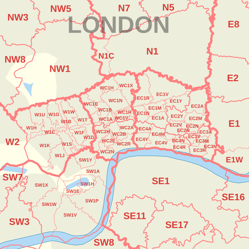
This section clears up one of the most common postcode confusions: central London does not have one postcode. Instead, several postcode districts can feel central depending on context.
If someone asks for “the central London postcode”, the honest answer is that there is no single code. ECand WCare the clearest central postal areas, but W1, SW1, SE1and NW1can also be central in everyday London terms.
Central London is a practical phrase, not one official postcode area. The answer depends on whether you mean postal geography, visitor geography, local authority areas, transport access or neighbourhood identity.
Why EC And WC Are The Historic Central Areas
ECstands for East Central, and WCstands for West Central. They are the clearest postal clues that you are looking at central London.
The central postcode districts are compact compared with many outer districts, which is why small differences such as EC1versus EC4or WC1versus WC2can matter.
Why W1 And SW1 Often Feel Central Too
Postcode systems and lived geography do not always speak the same language. W1covers parts of the West End, while SW1includes areas associated with Westminster, Victoria, St James’s, Belgravia and Pimlico.
So while ECand WCare the most literal central postal areas, W1and SW1are central in practical visitor terms.
Common Central London Postcode Examples
Useful examples include:
- EC1- Clerkenwell, Finsbury and Barbican.
- EC2- Moorgate and Liverpool Street.
- EC3- Monument, Tower Hill and Aldgate.
- EC4- Fleet Street and St Paul’s.
- WC1- Bloomsbury and Gray’s Inn.
- WC2- Covent Garden, Holborn and Strand.
- W1- Mayfair, Marylebone and Soho.
- SW1- Westminster, Belgravia and Pimlico.
Use these as orientation clues, not as exact boundaries.
Central London Postcode Map: How To Use One Without Overreading It
A central London postcode map is excellent for seeing broad district patterns. It is less useful for deciding whether a street “belongs” to a neighbourhood in a cultural, property or local-authority sense.
The GLA’s central postcode district map is helpful because it shows central London postcode districts in relation to wider London geography.
Takeaway:Central London is best read as a cluster of postcode districts, not a single postcode.
London Postcode Districts Vs Neighbourhoods And Boroughs
This section explains the biggest real-world trap: postcode districts are not the same as neighbourhoods or boroughs. Knowing that prevents many bad assumptions.
A postcode is a postal geography. A borough is a local government area. A neighbourhood is often a looser social, historical or property-market identity.
If borough names themselves are confusing, our guide to London borough name meaningsexplains where names such as Camden, Hackney, Southwark, Westminster and Islington come from.
Those three systems can overlap, but they are not designed to match.
Why Postcodes Do Not Line Up Neatly With Boroughs
London boroughs are administrative areas. Postcodes were created for mail routing and delivery.
That means a postcode district can cross borough boundaries, and a borough can contain several postcode districts. The ONS treats postal geography as useful for statistical linking, but it is a different kind of geography from local authority districts and wards.
A Simple Postcode-Vs-Borough Example
A postcode district such as NW10 can point you towards north-west London, but it does not automatically tell you which London borough the address is in. To confirm the borough, you need the exact address or a postcode-to-local-authority lookup.
That distinction matters because a postcode is built for postal delivery, while a borough is used for local government, council services and administrative boundaries.
Why One Neighbourhood Can Have Several Postcode Districts
Many London neighbourhoods spread across more than one district. A local area might be known by one name in everyday speech but split across several postcode districts for delivery.
This is why someone searching for “Camden postcode” or “Chelsea postcode” may find several possible answers. The correct code depends on the exact address.
Why One Postcode District Can Cover Several Local Identities
The reverse is also true. One postcode district can include several recognised local areas.
A district such as NW10does not equal one neighbourhood. It covers a wider postal district containing several local identities.
Example: NW10 And The Willesden/Harlesden/Neasden Area
NW10is a useful example because people often ask, “What area is NW10?” A practical answer is that NW10 covers parts of north-west London associated with places such as Willesden, Harlesden, Neasden, North Acton and Kensal Green.
But NW10 is not identical to any one of those names. It is a postcode district that overlaps several local identities.
Expert’s Take:The biggest mistake in postcode guides is treating a postcode district like a neighbourhood border. In London, it is safer to say a postcode gives a strong location clue, not a final identity.
Takeaway:Use postcodes for location clues and delivery accuracy, but use boroughs and neighbourhood names for civic and local identity.
London Postcode List By Area
This section gives you a practical, readable postcode list without turning the page into a directory. The aim is orientation, not replacing an official postcode finder.
London postcode lists are useful when you want to understand broad patterns. They are less useful when you need the exact postcode for a building.
The place names below are common area associations, not official boundary definitions. Always check the full postcode for a specific address.
Tip: If you are using this as a reference list, use your browser’s search function to find a district quickly. On most devices, that is Ctrl+F or Command+F.
East And East Central London Examples
| District | Commonly associated areas |
| E1 | Whitechapel, Stepney, Mile End |
| E1W | Wapping |
| E2 | Bethnal Green, Shoreditch |
| E3 | Bow, Bromley-by-Bow |
| E4 | Chingford, Highams Park |
| E5 | Clapton |
| E6 | East Ham |
| E7 | Forest Gate, Upton Park |
| E8 | Hackney, Dalston |
| E9 | Hackney, Homerton |
| E10 | Leyton |
| E11 | Leytonstone |
| E12 | Manor Park |
| E13 | Plaistow |
| E14 | Poplar, Millwall, Isle of Dogs, Docklands |
| E15 | Stratford, West Ham |
| E16 | Canning Town, North Woolwich, Docklands |
| E17 | Walthamstow |
| E18 | South Woodford |
| E20 | Olympic Park |
| EC1 | Clerkenwell, Finsbury, Barbican |
| EC2 | Moorgate, Liverpool Street |
| EC3 | Monument, Tower Hill, Aldgate |
| EC4 | Fleet Street, St Paul’s |
North And North West London Examples
| District | Commonly associated areas |
| N1 | Islington, Barnsbury, Canonbury |
| N2 | East Finchley |
| N3 | Finchley Central |
| N4 | Finsbury Park, Manor House |
| N5 | Highbury |
| N6 | Highgate |
| N7 | Holloway |
| N8 | Hornsey, Crouch End |
| N9 | Lower Edmonton |
| N10 | Muswell Hill |
| N11 | Friern Barnet, New Southgate |
| N12 | North Finchley, Woodside Park |
| N13 | Palmers Green |
| N14 | Southgate |
| N15 | Seven Sisters |
| N16 | Stoke Newington, Stamford Hill |
| N17 | Tottenham |
| N18 | Upper Edmonton |
| N19 | Archway, Tufnell Park |
| N20 | Whetstone, Totteridge |
| N21 | Winchmore Hill |
| N22 | Wood Green, Alexandra Palace |
| NW1 | Regent’s Park, Camden Town |
| NW2 | Cricklewood, Neasden |
| NW3 | Hampstead, Swiss Cottage |
| NW4 | Hendon, Brent Cross |
| NW5 | Kentish Town |
| NW6 | West Hampstead, Kilburn, Queen’s Park |
| NW7 | Mill Hill |
| NW8 | St John’s Wood |
| NW9 | Kingsbury, Colindale |
| NW10 | Willesden, Harlesden, Kensal Green |
| NW11 | Golders Green, Hampstead Garden Suburb |
South East And South West London Examples
| District | Commonly associated areas |
| SE1 | Waterloo, Bermondsey, Southwark, Borough |
| SE2 | Abbey Wood |
| SE3 | Blackheath, Westcombe Park |
| SE4 | Brockley, Crofton Park, Honor Oak Park |
| SE5 | Camberwell |
| SE6 | Catford, Hither Green, Bellingham |
| SE7 | Charlton |
| SE8 | Deptford |
| SE9 | Eltham, Mottingham |
| SE10 | Greenwich |
| SE11 | Lambeth |
| SE12 | Lee, Grove Park |
| SE13 | Lewisham, Hither Green |
| SE14 | New Cross, New Cross Gate |
| SE15 | Peckham, Nunhead |
| SE16 | Rotherhithe, South Bermondsey, Surrey Docks |
| SE17 | Walworth, Elephant & Castle |
| SE18 | Woolwich, Plumstead |
| SE19 | Upper Norwood, Crystal Palace |
| SE20 | Penge, Anerley |
| SE21 | Dulwich |
| SE22 | East Dulwich |
| SE23 | Forest Hill |
| SE24 | Herne Hill |
| SE25 | South Norwood |
| SE26 | Sydenham |
| SE27 | West Norwood, Tulse Hill |
| SE28 | Thamesmead |
| SW1 | Westminster, Belgravia, Pimlico |
| SW2 | Brixton, Streatham Hill |
| SW3 | Chelsea, Brompton |
| SW4 | Clapham |
| SW5 | Earl’s Court |
| SW6 | Fulham, Parsons Green |
| SW7 | South Kensington |
| SW8 | South Lambeth, Nine Elms |
| SW9 | Stockwell, Brixton |
| SW10 | West Brompton, World’s End |
| SW11 | Battersea, Clapham Junction |
| SW12 | Balham |
| SW13 | Barnes, Castelnau |
| SW14 | Mortlake, East Sheen |
| SW15 | Putney, Roehampton |
| SW16 | Streatham, Norbury |
| SW17 | Tooting |
| SW18 | Wandsworth, Earlsfield |
| SW19 | Wimbledon, Merton |
| SW20 | South Wimbledon, Raynes Park |
West And West Central London Examples
| District | Commonly associated areas |
| W1 | Mayfair, Marylebone, Soho |
| W2 | Bayswater, Paddington |
| W3 | Acton |
| W4 | Chiswick |
| W5 | Ealing |
| W6 | Hammersmith |
| W7 | Hanwell |
| W8 | Kensington |
| W9 | Maida Vale, Warwick Avenue |
| W10 | Ladbroke Grove, North Kensington |
| W11 | Notting Hill, Holland Park |
| W12 | Shepherd’s Bush |
| W13 | West Ealing |
| W14 | West Kensington |
| WC1 | Bloomsbury, Gray’s Inn |
| WC2 | Covent Garden, Holborn, Strand |
When To Use A List And When To Use A Postcode Finder
Use a postcode list when you want to understand London geography. Use an official postcode finder when you need the correct code for a real address.
Royal Mail’s Postcode Finder can be used to look up an address or postcode from the details you know, including partial address details.
Takeaway:Lists help you learn the pattern; postcode finders help you get the exact answer.
How To Use A London Postcode Map
This section shows how to use postcode maps well without mistaking them for legal or cultural boundary maps. A map is excellent for orientation, but it still needs interpretation.
London postcode maps are especially helpful when you are comparing hotel locations, property areas, delivery zones, or neighbourhood names you do not know yet.
Interactive Maps Vs PDF Maps
An interactive postcode mapis best when you want to zoom, search or compare districts. A PDF postcode mapis best when you want a fixed reference or printable overview.
The GLA postcode district mapsare useful because they show postcode districts across London in a clear cartographic format.
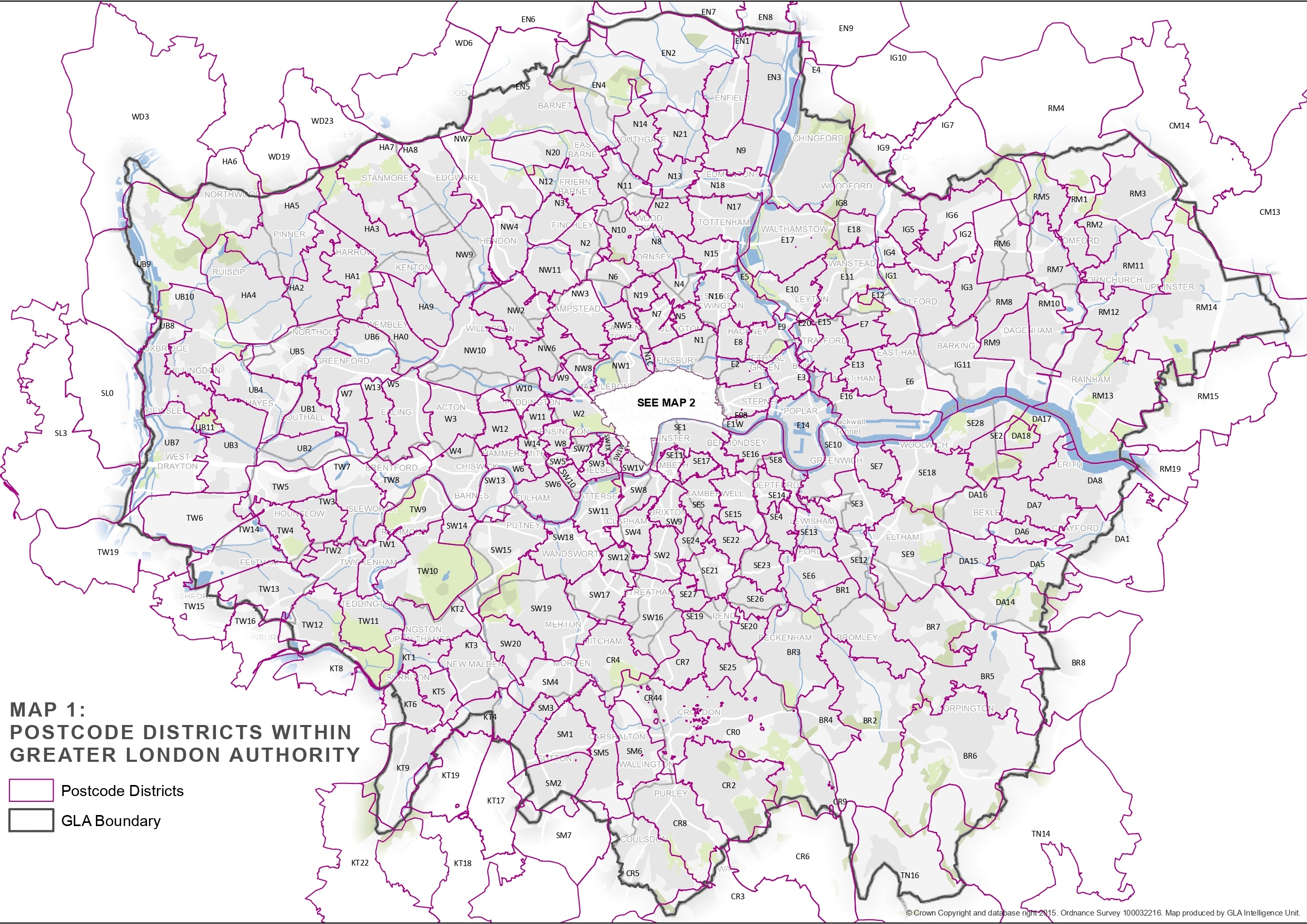
What Postcode Maps Show Well
Postcode maps are good for:
- Spotting broad area patterns.
- Seeing which districts touch each other.
- Understanding why a district may cover several neighbourhood names.
- Comparing central and outer London postcode families.
They are particularly helpful for visual learners who find lists hard to interpret.
What Postcode Maps Can Mislead You About
Postcode maps can mislead you if you treat them as exact neighbourhood borders. A line on a map may show a postal district edge, not where locals believe one area ends and another begins.
They can also imply that postcode numbers move neatly out from the centre. London’s numbering is more historical and operational than perfectly radial.
Greater London Boundary Vs London Postal Districts
Greater London is a government area. The London postal district is a postal system. They overlap, but they are not identical.
This is where a London mapbecomes especially useful: it lets you compare postcode areas with borough boundaries, the Thames, central London and outer London in one view.
Some places inside Greater London use postcode areas outside the familiar E, EC, N, NW, SE, SW, W and WC set. Examples around outer London can include areas such as CR, HA, IG, RM, SM, TW, UBand others.
Outer London And London-Adjacent Postcode Areas
Not every address people think of as “London” uses one of the historic London postal areas. Some outer London or London-edge locations use postcode areas that are also associated with neighbouring towns or wider regions.
| Outer postcode area | Common London connection |
| BR | Bromley-area addresses |
| CR | Croydon-area addresses |
| DA | Dartford/Bexley-side outer areas |
| EN | Enfield-area addresses |
| HA | Harrow-area addresses |
| IG | Ilford-area addresses |
| KT | Kingston-related outer areas |
| RM | Romford-area addresses |
| SM | Sutton-area addresses |
| TW | Twickenham/Hounslow-side areas |
| UB | Uxbridge/Southall-side areas |
| WD | Watford-side edge cases |
These are useful when comparing Greater London with the London postal district. They should not be treated as a separate “official London postcode list” without checking the exact address.
How To Use Postcodes When Choosing An Area In London
- Booking a hotel:District, nearest station and journey time
- Moving to London:District, borough, transport links and full address
- Sending post:Full postcode only
- Comparing areas:Postcode district plus borough and neighbourhood context
- Using a map:Postcode district boundaries, not neighbourhood assumptions
Use the postcode area for broad orientation, the district for neighbourhood research, and the full postcode for exact address checks. For example, SW tells you the address is broadly south-west London, SW19 points you towards Wimbledon or Merton, and the full postcode tells you the exact delivery area.
Takeaway:A London postcode map is a brilliant orientation tool, but it should not be treated as a borough map or neighbourhood constitution.
Famous London Postcode Examples
This section grounds the system in familiar London places. Concrete examples make postcode logic easier to remember than abstract rules.
Some London postcodes have become shorthand for landmarks, institutions, districts or cultural associations.
SW1A And Westminster Landmarks
SW1Ais one of the best-known London postcode sub-districts because it appears around the heart of national government.
The familiar format SW1A 2AAis commonly associated with 10 Downing Street. The broader lesson is that SW1Apoints to a highly specific central Westminster postal subdivision, not simply “south-west London” in the everyday sense.
SW19 And Wimbledon
SW19is widely associated with Wimbledon. This is a good example of a postcode district becoming a cultural shorthand.
Still, the full postcode is what matters for exact navigation or delivery. SW19alone is a district, not a complete address.
E14 And Canary Wharf
E14is strongly associated with Poplar, Docklands, the Isle of Dogs and Canary Wharf. It is one of the clearest examples of a postcode district carrying modern business and skyline associations.
For visitors, E14usually signals east London’s docklands geography. For delivery, the full postcode remains essential.
EC1, EC2, EC3 And EC4 In The City
The ECdistricts are compact but important. They cover much of London’s historic and business core around the City and nearby central districts.
Small changes matter here. EC1and EC4are both central, but they do not point to the same streets, institutions or visitor routes.
NW1, W1 And Tourist London
Many tourist-heavy parts of London are not in EC or WC. NW1can include Camden and Regent’s Park-related areas, while W1covers parts of the West End.
This is why “central London postcode” searches often produce several valid-looking answers.
Takeaway:Famous postcodes are useful landmarks, but the full code still matters when you need precision.
London Postcodes Vs ZIP Codes
This section answers a common international search query directly: London does not have a 5-digit ZIP code. Asking for one usually leads to the wrong result.
The correct term in the UK is postcode.
Why “5 Digit ZIP Code London” Is The Wrong Question
A London postcode is not a five-digit number. It is an alphanumeric code with a space separating the outward and inward parts.
Examples of valid London-style formats include:
- SW1A 1AA
- E14 5AB
- WC2N 5DU
- NW10 7AQ
If a form forces a five-digit ZIP code for a London address, the form is probably designed for US addresses or needs its country setting changed.
How To Write A London Postcode In An Address
A simple London address format usually places the postcode at the end, after the post town line.
Example format:
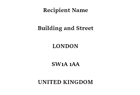
For domestic UK mail, “United Kingdom” is not needed. For international mail, include it.
What International Senders Should Check Before Posting
Before sending something to London from overseas, check:
- The full street address.
- The post town line.
- The full postcode with the space.
- The country line for international mail.
- The recipient’s name or organisation.
For exact lookup, use Royal Mail or the address source provided by the recipient.
Takeaway:London has postcodes, not ZIP codes, and the full alphanumeric code is the one that matters.
How To Find The Correct London Postcode
This section turns postcode knowledge into action. You will know which tool to use depending on whether you need a broad area, a district, or an exact address.
| Need | Best source |
| Exact postcode for an address | Royal Mail Postcode Finder |
| Correct UK address formatting | Post Office address guidance |
| London postcode district map | Greater London Authority postcode map |
| Postcode-to-borough/statistical lookup | ONS Postcode Directory |
| Coordinates or data export | ONS / Ordnance Survey-based datasets |
The best source depends on your task.
Use Royal Mail For Exact Address Verification
Use Royal Mail’s Postcode Finderwhen you need the correct postcode for a specific address. It is the most practical source for everyday address-level checking.
This matters for:
- Posting letters or parcels.
- Filling in official forms.
- Checking an address before travel.
- Avoiding errors in building names or flat numbers.
Use Maps For Area-level Orientation
Use a postcode map when your question is broader:
- “Where is SW19?”
- “How far west is W6?”
- “Is E14 near central London?”
- “Which districts surround NW10?”
Maps answer orientation questions better than address finders.
Use Postcode Datasets Only If You Need Data Analysis
Use official datasets if you need research, statistics or mapping rather than everyday lookup. The ONS Postcode Directoryrelates current and terminated UK postcodes to a range of administrative, electoral, health and other geographies, which makes it useful for data analysis rather than simple address lookup.
These resources are most useful for analysts, planners, journalists and developers. They are usually unnecessary for someone simply trying to post a letter.
Accuracy Warning For New Builds, Renamed Streets And Changed Addresses
Postcodes can change, and new addresses may take time to appear across every third-party map or database. The safest habit is to verify the full postcode against the address source or Royal Mail before using it for delivery.
ONS notes that postcodes are subject to continuous change because of new addresses, large-user postcodes, address-limit management and recoding. That means older maps, copied lists and third-party databases can sometimes lag behind official records.
Do not rely on an old screenshot, a property listing excerpt, or a copied postcode from a nearby building if accuracy matters.
Takeaway:Use Royal Mail for exact addresses, maps for orientation, and official datasets for analysis.
Frequently Asked Questions About London Postcode Areas
How Do London Postcodes Work?
London postcodes narrow an address from a broad postal area to a district, then to a sector and final delivery unit. The part before the space is the outward code, and the part after the space is the inward code.
How Do You Read A London Postcode?
Read it left to right: area, district, sector, then unit. In SW1A 1AA, SWis the area, SW1Ais the sub-district, 1is the sector, and AAis the unit.
What Are The Postcode Zones In London?
The main London postal areas are E, EC, N, NW, SE, SW, W and WC. They are postal areas, not transport zones or borough boundaries.
What Is The Central London Postcode?
There is no single central London postcode. ECand WCare the clearest central postal areas, but W1, SW1, SE1and NW1can also feel central.
What Does SW1 Mean In London?
SW1is a South West London postcode district associated with Westminster, Victoria, Belgravia, Pimlico and nearby government or central London landmarks.
What Area Is NW10 In London?
NW10covers parts of north-west London associated with Willesden, Harlesden, Neasden and Kensal Green. It is a postcode district, not one single neighbourhood.
What Is A London Postcode Example?
A well-known London postcode example is SW1A 1AA. It shows the usual UK format: outward code before the space and inward code after the space.
What Is The Difference Between A Postcode Area And District?
The postcode area is the opening letter or letters, such as SW. The postcode district adds the number, such as SW1or NW10.
Do London Postcodes Match Boroughs?
Not reliably. Postcodes are postal delivery geographies, while boroughs are local government areas. They often overlap, but they were not designed to match.
Does London Use ZIP Codes?
No. London uses UK postcodes, which combine letters and numbers. ZIP codes are used in the United States.
What Is The 5 Digit ZIP Code For London?
London does not have a 5-digit ZIP code. Use the full UK postcode for the specific London address instead.
How Can I Find A London Postcode?
Use Royal Mail’s Postcode Finder for a specific address. Use a London postcode map when you only need broad area or district orientation.
What Is The Difference Between London Postcodes And Greater London Postcodes?
The historic London postal areas do not cover Greater London perfectly. Some outer London places use postcode areas such as CR, HA, IG, RM, SM, TWor UB.
The Bottom Line
London postcodes make sense once you stop reading them as random labels and start reading them as a layered postal code. The outward code gives you the broad area and district; the inward code narrows the address to a much smaller delivery unit.
For everyday London life, postcode districts such as SW1, E14, NW10and WC2are useful shorthand. For posting, forms, deliveries and official records, only the full postcode is precise enough.
The simplest rule is the most reliable one: use postcode areas to understand London, and use the full postcode to find the exact address.
Jump to
London Postcode Areas Explained: How The Codes Work
What Is A London Postcode?
How To Read A London Postcode
The Main London Postcode Areas
Central London Postcodes: EC, WC, W1, SW1 And SE1
London Postcode Districts Vs Neighbourhoods And Boroughs
London Postcode List By Area
How To Use A London Postcode Map
Famous London Postcode Examples
London Postcodes Vs ZIP Codes
How To Find The Correct London Postcode
Frequently Asked Questions About London Postcode Areas
The Bottom Line

James Rowley
Author
James Rowley is a London-based writer and researcher covering London life, cultural geography, London travel, live London webcam pages and selected public figures across entertainment, sport, business and public life.
For over 15 years, he has focused on verified sources, first-hand local context and clear explanations that help readers understand both places and people more deeply. His work combines street-level London knowledge with careful research into career credits, media work, business interests and, where relevant, transparently explained net worth estimates.
He writes and reviews articles published on LondonWebcam.
Latest Articles
Popular Articles