

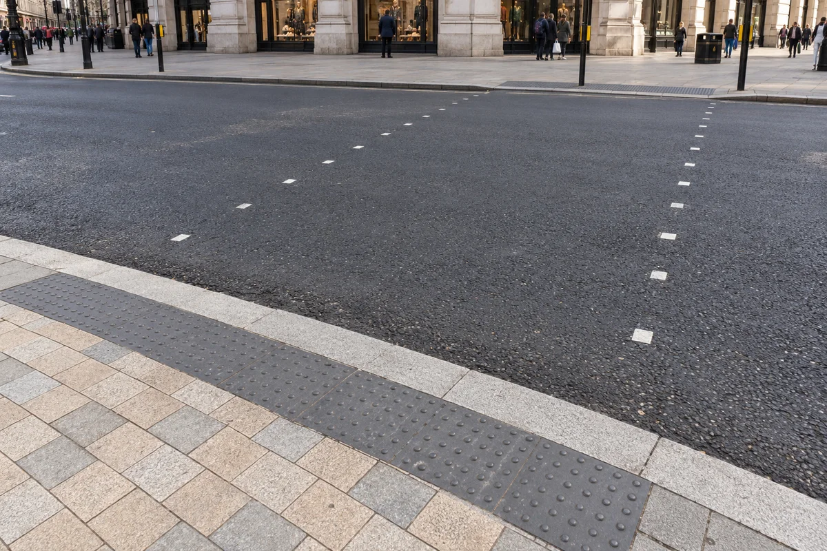
Where does the crossing actually begin?
Separate the kerb, the paving joints and the small crossing marks. They describe different boundaries. A still example cannot establish a signal phase or whether it is safe to cross; that decision requires the street itself.
Corners make the crossing
Begin at a corner. A corner is where two street edges meet, and a crossing is the line that can link pavement edges. At Piccadilly Circus or Parliament Square, start with the pavement rather than the traffic: find the visible corner, follow the kerb to the crossing markings, and see which opposite edge they reach. The shape is evidence of geometry; the signal and crossing type provide further context.
The kerb is the raised edge between pavement and carriageway. It is easy to overlook because it can run continuously around a corner, but it is one visible edge of the junction. Follow it until it turns to locate a corner; a crossing itself is identified by its layout and markings, not by extending the kerb line across the road.
Corners also do practical work. They widen the pavement for people waiting, and they set the angle at which a crossing meets the carriageway. A rounded corner and a sharp one give the same junction a different feel from the camera, even when the road itself is unchanged.
The frame may hide a signal, overlap two crossings or leave the far corner outside the picture. Naming those limits is part of reading the geometry accurately. A junction described without its missing parts is a diagram, not an observation.
The parts of a junction
A junction is made of a small number of parts, and each does a job. The kerb separates pavement from carriageway. The corner connects two street edges. Crossing markings show the marked area. A stop line marks the point where vehicles must stop when required. The refuge island is a small platform within the carriageway that can let a crossing take place in stages.
Any of them can be partly outside the crop. The stop line may be visible while the signal head that controls it is not. One crossing may appear alone when a second meets the same corner just beyond the frame. An island may be hidden behind a large vehicle at the moment of capture.
Reading the visible parts and naming the hidden ones is a complete exercise. It needs no claim about the traffic, the time or the people, and it produces a description that survives a second look at the same junction.
Each part earns its place by connecting the others. A kerb without a visible corner still marks the edge of the carriageway; a corner without a crossing still shows where two streets meet; a crossing without an island still links two edges. Read the connections you can see, and treat the rest as absent rather than assumed.
What a refuge island changes
A refuge island deserves particular care, because the rule attached to it is narrower than it first appears. On a zebra crossing with a central island, the Highway Code treats the layout as two separate crossings. Rule 20 adds that someone crossing waits on the island, then applies the zebra rule again to the second half.
That two-stage rule belongs to the zebra layout with a central island, and it should not be generalised to every island. The Department for Transport’s crossing guide notes that signal-controlled crossings with central islands can operate as one crossing when the routes line up, or as two when they are staggered. If the type is unclear, describe the visible geometry without applying a rule that the crop cannot establish.
The practical point for a camera reader is that a small platform in the middle of the road does not, by itself, tell you which rule applies. The crossing markings, the signals and the layout all contribute, and some of them may be outside the frame.
Read movement across the space
A short clip can show how people gather at a corner and move between visible pavement edges. That pattern reveals entry and exit points within the junction, and it stays a pattern of public space rather than a judgement about any individual. Follow the crowd as a group, not as a set of cases.
The one boundary worth stating is close to the rule it belongs to: when crossing a real road, the signal and the traffic at the roadside govern the decision, and the applicable rule is the one for the crossing in front of you. A camera view is not a substitute for looking at the road you are about to cross.
Keep the clip’s claims modest. It can show that movement occurred at a place within an interval. It cannot show how long anyone waited, whether the wait was typical, or which crossing rule was in force.
Compare two junctions
Piccadilly Circus brings several roads into one frame; Parliament Square spreads a civic space around a wide carriageway. Compare one fixed feature in each — a corner, an island, a crossing line — and describe how it connects the visible edges.
Finish with one relationship the frame shows and one detail it leaves out. A corner that links two kerbs but hides the far crossing is a good pair. So is an island that sits in the carriageway while the crossing type remains unclear.
The comparison is about geometry, not busyness. Two junctions photographed at different times cannot be ranked by traffic, but their layouts can be read side by side all the same.
Junction anatomy explorer
The schematic below is a code-native diagram of a crossing, not a camera view. Select a part to read its job, how it may appear from a camera, and what the crop can hide. The refuge island carries the strictest warning, because its rule depends on the crossing type.
Kerb
The kerb marks the edge between pavement and carriageway. It gives the junction a visible outline, though it does not by itself establish that a route is accessible.
It usually appears as a line where the surface changes, often read as a step in tone or a highlight along its top.
What the crop can hide: The kerb may run out of frame before the corner or crossing it belongs to, so its continuation has to be inferred rather than seen.
Part chosen: Kerb. It usually appears as a line where the surface changes, often read as a step in tone or a highlight along its top.
- Kerb. The kerb marks the edge between pavement and carriageway. It gives the junction a visible outline, though it does not by itself establish that a route is accessible. From a camera: It usually appears as a line where the surface changes, often read as a step in tone or a highlight along its top. What the crop can hide: The kerb may run out of frame before the corner or crossing it belongs to, so its continuation has to be inferred rather than seen.
- Corner. A corner is where two street edges meet. It anchors the junction; a marked crossing may connect it to another pavement edge. From a camera: Look for two kerb lines turning towards each other, sometimes rounded rather than square. What the crop can hide: The far corner may sit outside the picture, and a second crossing meeting the same corner can be hidden entirely.
- Island or refuge. A refuge island is the small platform within the carriageway where a crossing meets the middle of the road. From a camera: It reads as a short platform between the two halves of a crossing, often with a kerb of its own. What the crop can hide: The island does not by itself establish the crossing type. On a zebra crossing with a central island the Highway Code treats the layout as two separate crossings; signal-controlled crossings with islands are arranged and governed differently. A vehicle may also hide the island at the moment of capture.
- Stop line. The stop line is the transverse marking where vehicles are expected to wait before a signal or a crossing. From a camera: It appears as a line across a lane, with vehicles gathered upstream of it. What the crop can hide: The signal head that governs the line may be outside the frame, so the marking is visible without its controller.
- Crossing area. A marked crossing area connects pavement edges. Its markings help identify the crossing layout, but do not reveal every signal or rule governing it. From a camera: It appears as parallel stripes or studs running between the kerbs, with the corners at either end. What the crop can hide: The far end, a signal, or a second crossing may be missing from the frame, so one crossing can read as the whole junction.
Sources & further reading
Official references inform this guide. Check the responsible organisation for current access, opening times and travel advice.